10/30/2012: Discovery has Landed!
Yup, we made Yuma this afternoon. Have a few pictures to post from our stay at the Meteor Crater, but we need to take them off the camera and share a few. Everything looks as well as expected on the the lot. We will began cleaning it up and getting settled in tomorrow. Today we were a little tired from going to the Rocky Horror Picture Show the night before. The Navahos are building a new casino on I-40 up by Twin Arrows, a relic from the Route 66 days. Stay tuned as we update.
Tuesday, October 30, 2012

Monday, October 29, 2012


New Mexico-The Land of Enchantment

 10-26-2012: We left Elk City, OK headed west through Amarillo and into New Mexico. There are some interesting land formations across the upper part of the state. From round flat mesas to higher longer mesas. Interstate 40 was built in the 60's, replacing the Mother Road-Route 66. We had travelled other parts of Route 66 before, so this was an addition to those trips. The first night in eastern New Mexico we stayed at Tucumcari. This was the first city in NM to be on Route 66. There are many of the older buildings and curious sights of the era lining the business route still being used today. From a tepee shaped curios shop to older motels, you feel like you stepped back in time. One old gas station has been restored and houses some older cars and trucks alongs with some interesting creations for travellers to look at and photograph. The RV park where we stayed had some older buildings out front which appeared to be apartments. Each one had it own carport and the house number was written in tiles in front of each door. They are not being used today, but stand in reflection of a living standard decades ago.
Onward across NM to AZ. We spent a second night in the RV park at the Dancing Eagle Casino located by Casa Blanca, NM. Pretty much uneventful. Get your players card-get a parking site for less. We didn't even unhook, knowing we would leave early the next morning.


Onward across NM to AZ. We spent a second night in the RV park at the Dancing Eagle Casino located by Casa Blanca, NM. Pretty much uneventful. Get your players card-get a parking site for less. We didn't even unhook, knowing we would leave early the next morning.


Thursday, October 25, 2012
 |
| Ozark Heritage Center in Salem, MO |
The fall colors are still in view but the peak has passed. Heading into Oklahoma from Missouri, was quite the contrast. Oklahoma hasn't changed, at least not in the full sense of reds and yellows. There were some hardwoods that were beginning to show their elegance, but most roadside trees were still green and the roadsides were still being mowed. Wind has been a factor as it continues to blow all across Oklahoma, buffeting the coach. We will continue our journey westward to AZ. Happy trails!!
 |
| Oklahoma roadside still green |
 |
| South Missouri showing it's color |
Wednesday, October 17, 2012
10/17/2012
Hello all. We made to Kansas City, MO this afternoon. Seems like we have been on the road a long time already, but it has only been ten days. We crossed the Missouri River from the north and continued south. We are staying at the "Square" RV Park. This is a return trip as we stayed here a couple of years ago. The fall colors in Missouri are lovely. Took a few pics and will post some as soon as we get them viewed and selected. It is already late tonight, so most likely later in the week.


From our last post, we have been to Bismarck, ND, Pelican Rapids, MN, Sutherland, IA and now Missouri. We did a big loop Springfield, MO to see friends before they departed to South Dakota. Had a wonderful time and even opened a few persimmons. For those not familiar with persimmons, they are a tree that grows locally in Missouri (and other states as well). The are not real tall but produce a small apple like fruit which has been used for years to predict the winter. Most persimmons are orange in color when ripe and can be eaten, (from what I understand), if you like them. There bark of the tree is rough and looks like tiled wood. When you open the fruit, they contain three (usually) flat seeds. When these seeds are cut open the long way, they reveal inside either a spoon, fork, or knife. A spoon represents a snowy winter, spoon = shovel. A fork indicates a milder winter with less snow. Fork = sieve. Lastly, the knife. A knife indicates an icy, windy winter. Henceforth, knife = cutting. The four seeds we opened all contained a spoon. Therefore, the winter in south Missouri (where the persimmons were picked), should be snowy and needing shoveling if the traditional prediction holds true. Take care family and friends!! Will try to get the pictures posted soon. Look for the reds, yellows and dark green grass contrast and the 'spoon' inside the seed. Later!!
Hello all. We made to Kansas City, MO this afternoon. Seems like we have been on the road a long time already, but it has only been ten days. We crossed the Missouri River from the north and continued south. We are staying at the "Square" RV Park. This is a return trip as we stayed here a couple of years ago. The fall colors in Missouri are lovely. Took a few pics and will post some as soon as we get them viewed and selected. It is already late tonight, so most likely later in the week.


From our last post, we have been to Bismarck, ND, Pelican Rapids, MN, Sutherland, IA and now Missouri. We did a big loop Springfield, MO to see friends before they departed to South Dakota. Had a wonderful time and even opened a few persimmons. For those not familiar with persimmons, they are a tree that grows locally in Missouri (and other states as well). The are not real tall but produce a small apple like fruit which has been used for years to predict the winter. Most persimmons are orange in color when ripe and can be eaten, (from what I understand), if you like them. There bark of the tree is rough and looks like tiled wood. When you open the fruit, they contain three (usually) flat seeds. When these seeds are cut open the long way, they reveal inside either a spoon, fork, or knife. A spoon represents a snowy winter, spoon = shovel. A fork indicates a milder winter with less snow. Fork = sieve. Lastly, the knife. A knife indicates an icy, windy winter. Henceforth, knife = cutting. The four seeds we opened all contained a spoon. Therefore, the winter in south Missouri (where the persimmons were picked), should be snowy and needing shoveling if the traditional prediction holds true. Take care family and friends!! Will try to get the pictures posted soon. Look for the reds, yellows and dark green grass contrast and the 'spoon' inside the seed. Later!!
Wednesday, October 10, 2012


10/10/2012-Well, another year, another journey. Left Washington Monday morning Oct. 8th for locations East. Passing through Snoqualmie Pass, the gray mountains and dark green firs were dotted with oranges and reds and yellows of changing leaves. We spent the first night in Haugan, MT. Couldn't beat the price. FREE!! Even with electric. The next morning we again head east and travelled along the Clark Fork River. This is a very pretty river with crystal clear water flowing ever so gently. We were even treated to an air show just outside Missoula. Some sky jumpers were making a practice run and we were fortunate to capture them making their descent. Yup!! Winter is coming to Montana. That is actually new snow on the caps of the mountains in the distance as we leave Bozeman. We didn't run into any on the roads, but we know the hills and roads will covered soon. Hopefully we will be headed south by then. We will continue to post as time allows and we get a few minutes and new pictures. Hopefully you will join us often!!

Tuesday, October 25, 2011
It's time!!
Yes, it is time again to head south. First night out we headed to Canyonland, OR, staying at the Seven Feathers Casino resort. Free shuttle to the casino (of course) and a very accessible site. Left there Oct 25th and headed to Reno. Actually we were staying just outside of Carson City, NV at the Silver City RV Resort. We even ventured a side trip and went to Virginia City and South Lake Tahoe. There was an older Casino in Virginia City which offered a 100 mile view and it was. We looked off in the distance a long way. Looking down the old boardwalk was like looking through a 'portal of time'. We didn't miss the fall colors either as we travelled through greens, yellows and reds most of the way here. Enjoy the pics, there will be more to come. Stay tuned!! 


Wednesday, April 13, 2011
Tucson North


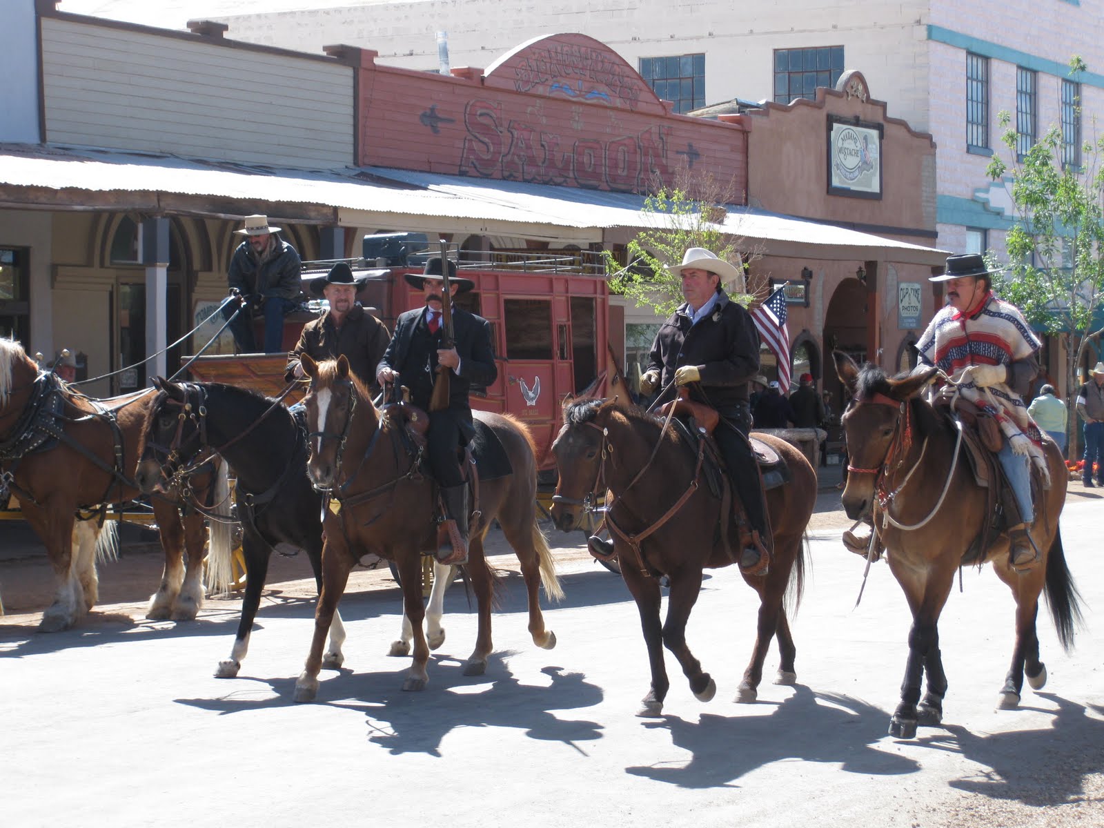


Arrived north of Tucson Thursday afternoon. We stayed at Catalina State Park (bottom picture) located at the base of the Catalina Mountains. Nice park with the mountains visible from all angles. We visited Mel, Kathy and Delores for the three days we were around. We had high winds on Friday, rain on Saturday (with snow, YES, snow) in the higher elevation where we were. We went to the Oracle Inn for dinner Saturday night and there was 5 to 6 inches of white stuff on cars sitting in the parking lot. All around on the ground and trees was a white, cold covering of snow. Luckily it didn't stick on the roads and we were not stranded. Sunday morning we took a jaunt south of Tucson to Bisbee and Tombstone. Bisbee is an old mining town with an operating copper mine (second from bottom picture on the right) still in existence today. It is built in a canyon and all the residents seem to live on a hill. Everyone has heard of Tombstone, home of the gunfight at the OK Corral. They have people and actors in period clothing all over the town. (Top center, left center picture). The boardwalks and old western buildings do much to convey the message one has 'stepped back in time'. There is an authentic Butterfield stage coach (top left picture) pulled by mules doing tours of the city. We splurged and took the stagecoach on a short ride through the streets of Tombstone. We stopped by 'Boothill' (top right picture) on our way out of town. There we viewed some old graves from Tombstone's historical past. Clantons, McClaurys, "China" Mary and other noted people. Well worth the visit, but back to Tucson.
Wednesday, April 6, 2011
Leaving Yuma
Chores are done, errands have been completed, laundry all dry and put away. Guess that means it is time to leave Yuma. Made one last trip to Los Algodones and said our goodbyes to Mexico. We will head to Tucson Thursday morning, hopefully before the windstorm that's supposed to be headed this direction. The lot is all secured and anything not nailed down is put away. Adios little car. Adios cactus, agave, plants and palm trees. Adios Yuma crunch and warm bright sunshine. Adios to all our Yuma family and friends. Catch you on the road!!
Sunday, March 20, 2011
Spring has Sprung


 Where have the past five months gone?? Good grief, almost time to head home and the blog needs to be updated. Where to begin?? Actually, it has been since November when our friends Linda and Cindy were here in Yuma and we enjoyed Thanksgiving 'out of a box'. It is well past time. We went to Quartzsite a couple of times in January. Our friend David from Idaho returned to Yuma and went to the RV rally 'in the desert' with us, after we were there to see Roger and Sue earlier. February arrived, and lo and behold, John and Rose showed up at our doorstep. (Actually at the driveway as they had their travel trailer and decied to check out Yuma for theit first time. We did some Geocaching as well as the Geocaching rally sponsored by S.W.A.G. in February. A couple of golf games, a bonfire in the desert and some card games rounded out the month. Now passed March, into April, and heading to 'countdown'. We haven't set an actual date for leaving Yuma, but time is near. Hopefully a more timely update to the blog. Rose has shamed us into it. Showed her a new forum for her to post to, and she is off and running. (John can't even catch her). But it's a good thing, if for nothing more than the inspiration.
Friday, November 12, 2010
Out of Texas


We finally fueled up and headed out of Texas. Anthony is the last city, or town, in Texas you pass through before crossing into New Mexico. We did actually cross into NM. Honest, we really did. See the sign?? It says welcome. This is where we actually crossed the Rio Grande, not much of river anymore, as it flows south from the mountains around Albuquerque. If we were to jump on I-25 headed north, we could follow it further. Alas, we parted ways in Las Cruces and continued West. New Mexico roads aren't a whole lot different from Texas, (or any where else actually) and we didn't travel a whole lot through New Mexico. Our ultimate destination was Arizona. The sign entering there also says welcome. (People are so friendly here, but that's another story, another time)!? The sun was setting again, so we decided to make an additional stop for the night in Eloy, AZ. This was outside of Casa Grande. We could have continued on, but didn't feel we had to fight the sun in our eyes and arrive Yuma in the dark and try to get setup. We opted for an early night and joined the party at the RV park in Eloy for cake and ice cream. (Halloween and a birthday to boot). A little walk with the doggies and we were all ready to turn in early. Yuma was looming on the horizon. Not long now!!
The Rio Grande and El Paso


El Paso city, on the Rio Grande. (You can almost hear the words to the old song here, huh)? There is almost 600 miles from San Antonio to El Paso. (548 according to the Texas map we picked up along the way). We are not in a real big hurry, so we stopped along the way and spent the night in an RV park outside of Balmorhea. Stopping before dark allowed us to grab a sunset picture and then a sunrise shot also. (Can you guess which is which)? I have hint for you. The one with the power pole is the sunrise. Unfortunately we couldn't move far enough right or left to get it out of view, so think of it as a marker. We headed out shortly after sunrise. The dogs had their breakfast and we had coffee. We couldn't get over the speed limit in Texas. 80 mph for cars and 65 mph for trucks and night time. We continued westward, along the Quitman Mountains. Do you see the Rio Grande?? We couldn't either. We needed to get closer to El Paso. There we got our 1st view of the Rio Grande. The center of the river is the boundry between the U.S. and Mexico. The mountains off in the distance are in Mexico. El Paso is a large industrial city, sprawled out through the valley, bordering the town of Juarez, Mexico. The Rio Grande is all that separates these two cities. Lots and lots of people live here. Lots and lots of traffic through the city. I would like to say it is the largest city on the border with Mexico, but our friend Linda was corrected when she posted this fact. Thus, I will refrain and we will move on.
Leaving San Antonio


Roads leave San Antonio every which way. West is our direction, so West we head. I-10 is a long and winding road. Not a whole lot of traffic once you get away from San Antonio. This was a relief as we motored on down the road. The Interstate road system commissioned by the Eisenhower admimistration in the late 50's and early 60's criss-crosses the U.S. in every direction. The road we travel follows through canyons cut from the rock, still baring the scars of the drill. It becomes quite long and even the puppies couldn't resist a nap.
Friday, October 29, 2010
SAN ANTONIO STROLL


Remember the Alamo, but take a San Antonio Stroll. We did this in two parts. First the Alamo where Santa Ana, self-proclaimed Mexican leader, with more than 2000 soldiers laid seige to less than 200 Americans trying to protect a fort and a mission on the San Antonio River in 1836. One of the protectors of the fort was Davy Crockett, alas, all perished when Santa Ana stormed the fort. The Long Barrack and the mission (The Alamo) is all that remains today. The 175th Anniversary of the fall of the fort is in 2011. Part two is the stroll along the famous "Riverwalk" in San Antonio. You actually walk along a man-made canal, about four feet deep, carved to relieve flood waters at one time. Don't know how long it actually is, but we walked it all, first one side and then the other. We even had lunch at the Casa Rio, the first restaurant to offer outside seating along the river in 1946. (You can recognize it by the colorful umbrellas on each table). It was a beautiful day, reaching into the high 70's, but the walk along the river was shaded and cooler than up above on the street. Paco and Pepe enjoyed that stroll too. They didn't have to walk though, as we carried them for security reasons. Tired little puppies by time we were done. The dogs too!!
Subscribe to:
Posts (Atom)